Ahora estás siguiendo a
Error al seguir a usuario.
Este usuario no permite que los usuarios lo sigan.
Ya estás siguiendo a este usuario.
Tu plan de membresía solo permite 0 seguimientos. Mejora tu membresía aquí.
Dejaste de seguir correctamente a
Error al dejar de seguir al usuario.
Has recomendado exitosamente a
Error al recomendar al usuario.
Algo salió mal. Por favor, actualiza la página e intenta de nuevo.
Email verificado correctamente.


bandung,
indonesia
Aquí son las 1:43 p. m.
Se unió el diciembre 22, 2022
0
recomendaciones
Geraldine Aradhana S.
@gesutantra
3,6
3,6
100%
100%

bandung,
indonesia
100 %
Trabajos finalizados
100 %
Dentro del presupuesto
100 %
A tiempo
10 %
Tasa de recontratación
GIS ENGINEER
Contacta Geraldine Aradhana S. sobre tu trabajo
Inicia sesión para comentar cualquier detalle por chat.
Portafolio
Portafolio


India Admisitrative Map


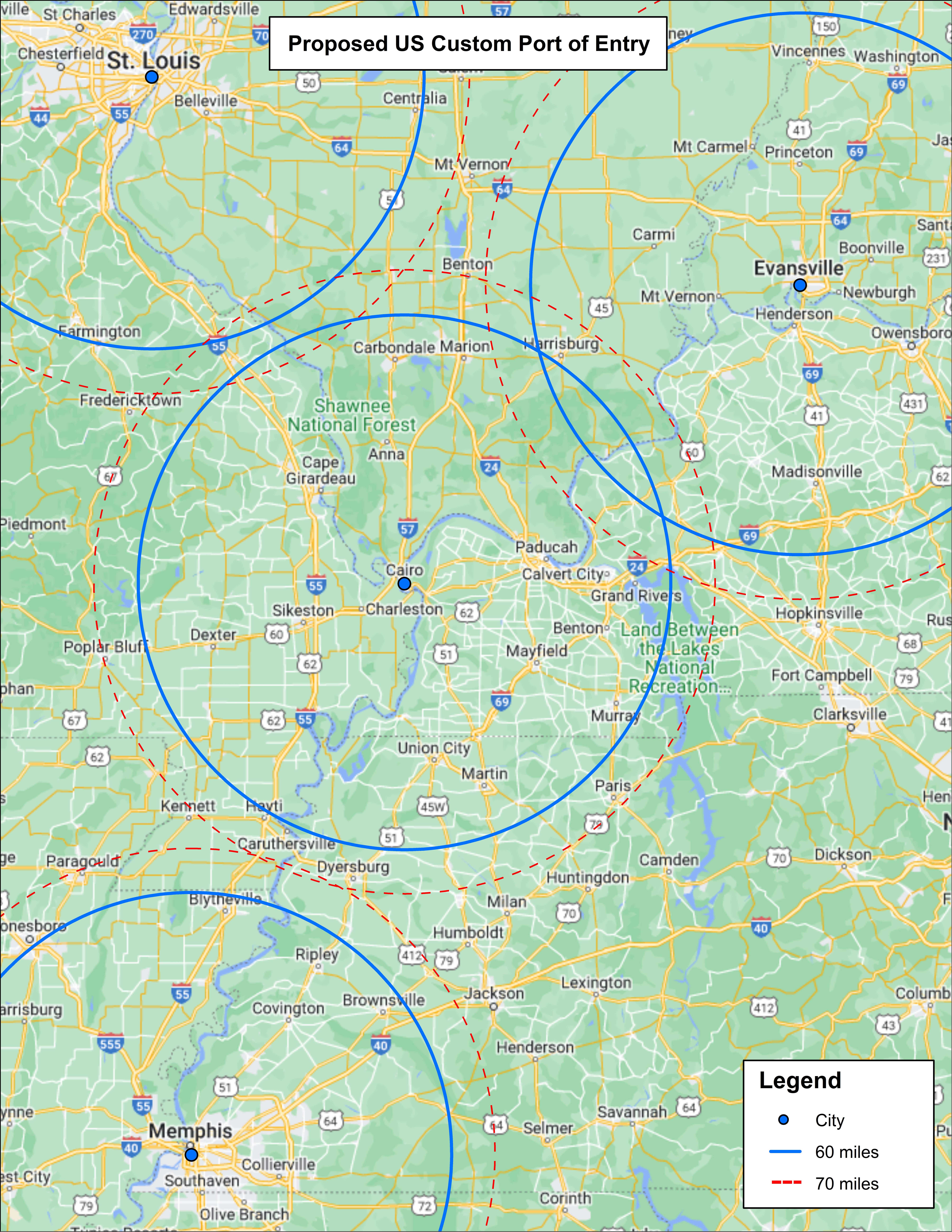
Buffer Analysis in USA


3D Map Sample

3D Map Sample


Poverty Distribution Map


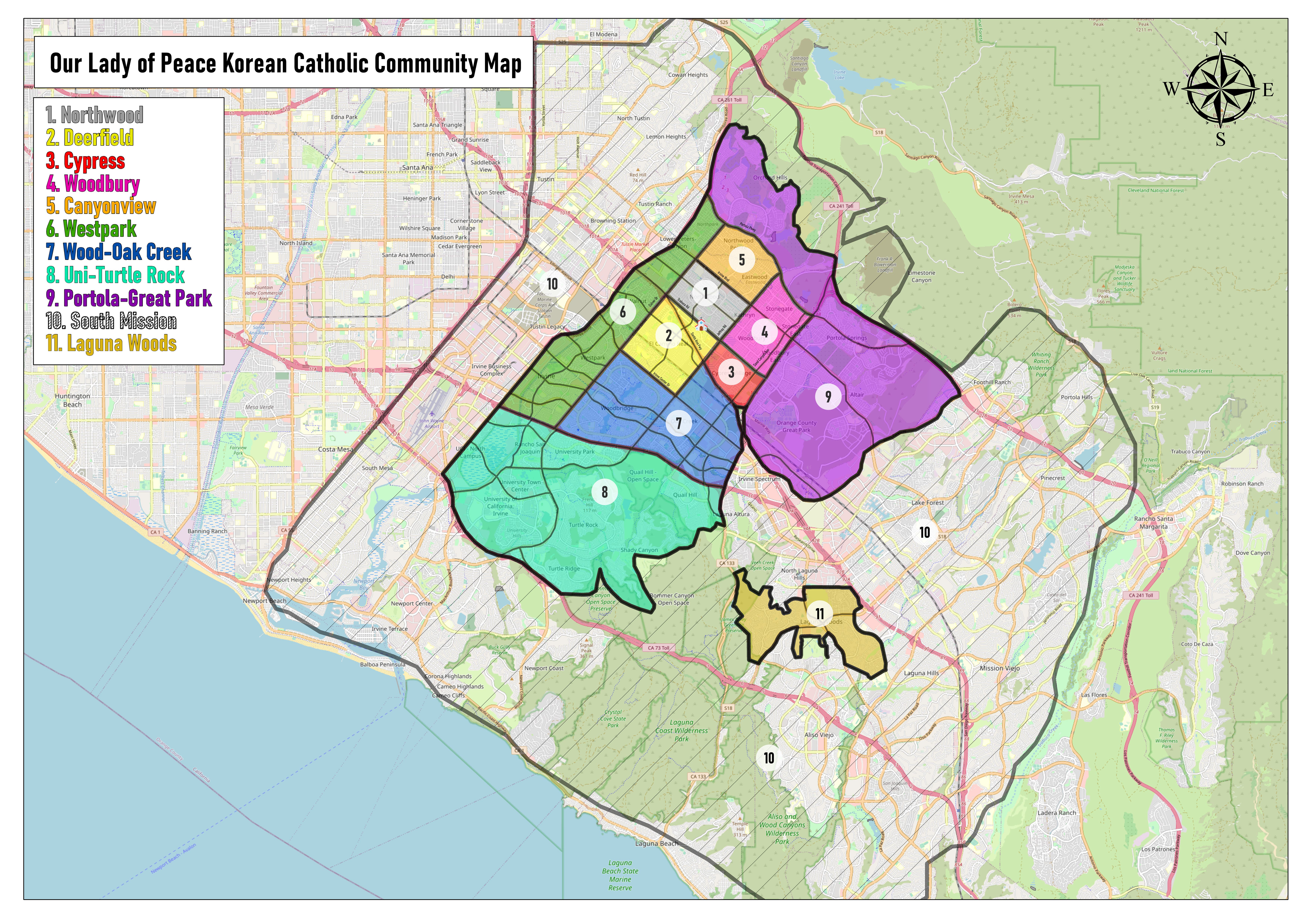
Our Lady of Peace Korean Catholic Community Map


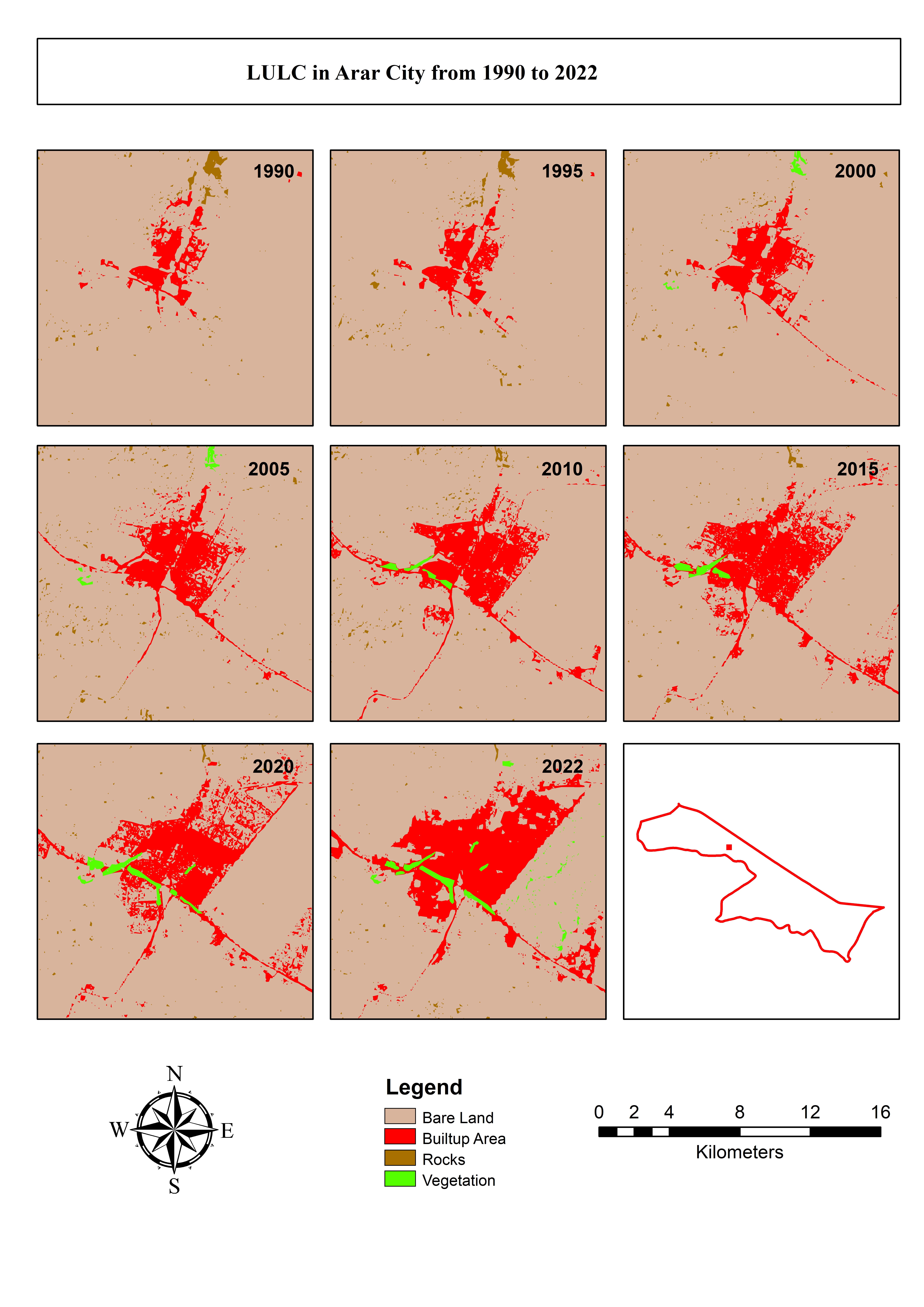
LULC Change in Northern Border Province, Saudi Arabia

LULC Change in Northern Border Province, Saudi Arabia

LULC Change in Northern Border Province, Saudi Arabia

LULC Change in Northern Border Province, Saudi Arabia


India Admisitrative Map


Buffer Analysis in USA


3D Map Sample

3D Map Sample


Poverty Distribution Map


Our Lady of Peace Korean Catholic Community Map


LULC Change in Northern Border Province, Saudi Arabia

LULC Change in Northern Border Province, Saudi Arabia

LULC Change in Northern Border Province, Saudi Arabia

LULC Change in Northern Border Province, Saudi Arabia
Comentarios
Cambios guardados
Mostrando 1 - 5 de 7 reseñas
₹2.500,00 INR
Cartography & Maps
Geolocation
Google Earth
Geographical Information System (GIS)
+1 más
H

•
$10,00 USD
Geographical Information System (GIS)
Google Earth


•
$125,00 USD
Geolocation
Geospatial
Geographical Information System (GIS)
ArcMap
ArcGIS
P
•
$50,00 AUD
Graphic Design
Cartography & Maps
Geospatial
Google Maps API
Geographical Information System (GIS)
Z

•
$84,00 USD
Cartography & Maps
Geographical Information System (GIS)
ArcGIS


•
Experiencia
GIS Engineer Contractor
abr 2023 - Presente
Soil Digitation using QGIS
Social Media Evaluator
dic 2021 - dic 2022 (1 año)
Reviewed targeted ads on social media and provide constructive, detailed feedback
on their content, appearance, relevance, overall quality as well as cultural relevance
in Indonesia
Student Intern
sept 2020 - jun 2022 (1 año, 9 meses)
-Analyzed Rainfall in Citarum Watershed
-Analyzed Land Cover (Vegetation and Building) in Citarum Watershed
-Analyzed Water flow in Citarum Watershed
-Analyzed Temperature in Citarum Watershed
-Digitized several areas in Java
-Land Mapping
Educación
Bachelor of Agricultural Technology
(5 años)
Calificaciones
QGIS Basic Trainer
Ram Telecom LLC
2023
Trained Ram Telecom LLC employees about QGIS Software during April 2023.
ArcGIS Online Course Tutor
Langen Teknik Satria
2023
Taught Intermediate ArcGIS skills about Rainfall Distribution Analysis (Spatial & Temporal) and Impervious Surface Area Analysis
ArcSWAT Online Course Tutor
Langen Teknik Satria
2023
Analysis of Hydrological Conditions in a Watershed Using the SWAT Model (Soil and Water Assessment Tools)
Publicaciones
Development of a map for land use and land cover classification of the Northern Border Region
The Egyptian Journal of Remote Sensing and Space Science
This study uses remote sensing data to investigate LULC in the Northern Border Region (NBR) in the Kingdom of Saudi Arabia. The purpose of this study is to obtain a better understanding of the patterns and drivers of changes in LULC in the NBR over the past three decades.
Contacta Geraldine Aradhana S. sobre tu trabajo
Inicia sesión para comentar cualquier detalle por chat.
Verificaciones
Principales habilidades
Explorar galerías similares
¡Invitación enviada correctamente!
¡Gracias! Te hemos enviado un enlace para reclamar tu crédito gratuito.
Algo salió mal al enviar tu correo electrónico. Por favor, intenta de nuevo.
Cargando visualización previa
Permiso concedido para Geolocalización.
Tu sesión de acceso ha expirado y has sido desconectado. Por favor, inica sesión nuevamente.